This is a great video that addresses a point I discussed in an earlier post - the perils of dam building on rivers in the face of climate change induced discharge/runoff changes. The video addresses the likely impacts on humans, as well as alternatives. One of the main messages is that we really need to carry about proper hydrological and climatic evaluation before building dams for short term gain.
In The Bleak Midwinter
It’s Boxing Day, the turkey
sandwiches are flowing, the family arguments are reaching a near Shakespearian
conclusion, and the drinking is continuing.
As usual, Father Christmas had a successful flight the other night, and
it seems appropriate in this festive blog post to focus on river discharge in
the Arctic, Father Christmas’ homeland.
Examination of 1936 to 1999 river
discharge data by Peterson, et al. (2002) shows a 7% increase in average annual
discharge of freshwater from the six largest Eurasian rivers that flow into the
Arctic Ocean. This change was correlated with changes in global mean surface
air temperature, and the authors concluding that these changes could have a
significant effect on thermohaline circulation in the Atlantic Ocean in the
future. Quite as to why this increasing trend has occurred is unclear, however McClelleand, et al. (2004) suggest four possible causes of this change: 1.
Increased moisture transport to higher latitudes in a warming climate; 2. Dam
construction and operation; 3. Permafrost thaw; and 4. Increasing forest fires.
Through a combination of observation and monitoring, they suggest that dam
construction, permafrost thaw and forest fires are all unlikely to be responsible
for changes in discharge, sensitivity analysis showing that the changes
required to enact current changes in discharge are unrealistic. Ultimately it is
suggested that increased moisture transport to higher latitudes from global
warming is the most likely conclusion, though there is great uncertainty.
This hypothesis is echoed by the
work of Wu, et al. (2005) who examine human influence upon changing Arctic
discharges. In running a complex climate
model to simulate arctic flows (HadCM3), they show that a model not forced with
anthropogenic factors does not produce the increases in discharge that have
been observed in the Arctic. Increasing
higher latitude precipitation as a result of anthropogenic warming is the most
likely factor to have forced increases in Arctic discharge. It is very
important we try and quantify these changes - a shut down in thermohaline
circulation in the North Atlantic would have catastrophic effects upon our
world’s climate.
At least Santa is surviving so far.
You'll Manage
The last post talked about
restricting building on floodplains as a way to manage climate change induced
changes in discharge, the idea being that a natural and free flowing river is
better suited to withstanding increases in discharge. A natural channel can
move dynamically and adjust flows to buffer against negative impacts of
increased discharge (Palmer, et al. 2008). However, the big problem is that
most rivers no longer exhibit flow regimes in line with historic flow regimes, such
as been the influence of humans with the construction of infrastructure such as
dams and levees. For example, Poff, et al. (2007) conclude that dams have changed
flow regimes in rivers across the USA – important for both humans and
ecosystems. Clearly, even without human
interventions, rivers have a point at which they can no longer deal with large
increases in discharge, but our own human interventions are making it worse.
We can’t have it both ways – we
can’t cause increases in discharge from climate change, and then prevent
natural processes that might mitigate this change from occurring. When I talk
about human intervention, I mean many different things: urbanisation on a
floodplain, building dams/reservoirs, and excessive water
withdrawals/additions. All of these things alter floodplains such that rivers
are less able to buffer and adapt to changes in discharge. These changes leave
humans at risk through increased flood risk and contamination of water supplies
used for consumption. Changes in yearly flow regimes can also have impacts on agricultural
production, particularly in irrigation fed agriculture.
Ecosystems are also at risk too.
Though they are clearly biased towards certain conclusions, the WWF (2004) and
their beautifully named ‘Dam Right’ initiative identified 21 river basins at
risk of severe ecological degradation, the cause being multiple (six and over) large
dams either constructed, planned, or under construction within these basins. Palmer,et al. (2008) have shown that it is likely basins impacted by dam or extensive
development will suffer greater changes in discharge and water stress in the
face of climate change, as opposed to naturally free flowing rivers – see Figure
1.
 |
| Figure 1 - Relative percentage (%) change in discharge in large river systems around the world, from present to 2050, under two different climate models. From Palmer, et al. (2008). |
A Long Wey to Go
It is time to diverge from pure
theory, and try to illustrate a few points with a case study. In my last post, I talked about the River Wey (a
tributary of the Thames) and how urbanised floodplains have exacerbated
flooding along some parts of the river. I have been studying this river in some
detail for the last 6 months, and it illustrates some of the points I have been
talking about so far.
The UKCP09 climate projections
are often used in thinking about the potential effects of climate change on
water resources in the UK (Christierson, et al. 2012). These projections
suggest a variety of changes, but the general pattern is an increase in
evapotranspiration and the intensity of rainfall events. For the majority of
its length, the Wey is bounded by ample natural floodplain, making any flooding
slow moving and of a slow intensity – however the channel is more constrained
in some urban areas and flooding can be faster moving and intense (EnvironmentAgency, 2010).
The Wey flooded considerably in
some urban areas during late 2013/early 2014. Wang, et al., (2012) have
suggested that the weather leading to recent flooding on the River Wey may be
associated with a pattern of increasing storm intensity in the North Atlantic,
consistent with patterns of climate change. Data suggests that the highest
flows since the extreme floods of September 1968 (a 1 in 1000 year event) were
recorded on the River Wey (Met Office and Centre for Ecology and Hydrology, 2014). This is a very large change in
discharge and runoff, likely forced by climate change. At different points
along the river, thousands of homes and businesses were affected by floodwater.
If the rainfall event that caused
these flows has been influenced by climate change, we need to act sooner rather
than later, or this level of flooding could become a common occurrence. Things
need to change on a number of scales; all the way through from local building
on the River Wey’s floodplain to global emissions of greenhouse gases. Herein
lies the problem – there are so many different actors involved, that just solving
changes in discharge caused by climate change along a small catchment is very
difficult.
Wall to Wall
The news today is
dominated by the headline ‘Treasury unveils £2.3bn for (flood) schemes to protect homes’.
In the light of recent flooding during late 2013/early 2014, this may seem a
prudent move by the government. As we have seen, climate science and
hydrological modelling suggests discharge and runoff (and thus flood regimes)
are going to change in the face of climate change. Reynard, et al. (2001) carried out hydrological
modelling based on climate change scenarios for the largest rivers in the UK
and predicted increases in the frequency and magnitude in the flooding of these
rivers. Interestingly, they find that land use is the largest influence (bar
climate) on the flood regimes; with an increase of forest in a catchment
flooding is less severe, but an increase in urban surfaces increases both the
frequency and magnitude of flooding. Clearly, land use is hugely important for
addressing future riverine flooding in the UK.
It may sound overly
cynical, but the announcement made by the UK Treasury today is little more than
political spin – the money is not new. The
Committee on Climate Change noted that these new schemes (in the
Thames Estuary, Oxford, Somerset) are perhaps missing the point, and that this
money should maybe go into managing existing defences. Hard engineering seems
to be the overriding strategy in the new schemes, and this likely reflects the
link between flood disasters and the demand for public policy (Johnson, et al. 2005). After the floods last
winter, the government wants to appear strong on the issue to the electorate –
what better way than to allocate money to good old fashion hard engineering? I
have no doubt these schemes will have been properly researched and will protect
some properties, but hard engineering is unlikely to be a long term answer to
changes in flood regimes.
As Reynard, et al. (2001) have suggested, land use
is a very important issue that we should be focusing on, in the form of
catchment management, and preventing overdevelopment on floodplains. Rivers
with wide, natural floodplains have a far greater natural capability to deal
with flooding. For example, take the River Wey (Surrey), a tributary of the
Thames that experienced some severe flooding last winter. The majority of the
river has ample natural floodplain, and such severe flooding did not occur in
these areas. However, there are a few pinchpoints where the floodplain has been
built on. Urban surfaces like concrete and tarmac have no ability to absorb
water, and thus flooding occurred heavily at these parts of the river – see the
picture of Guildford car park under many feet of water.
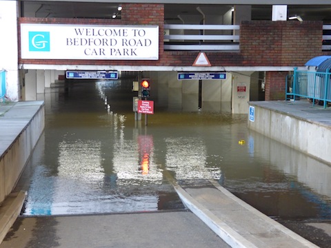 |
| Urbanised foodplain = underwater. |
Today’s new funding
is mostly a load of spin, and seems to very focused on making a political
point, and trying to win the hearts of the electorate before the next election.
Such flood projects have their place, but long term we need to focus on why we
have made property so susceptible to flooding, and why we are allowing changes
to the hydrological cycle to occur. If you don’t want to be flooded, don’t live
on a floodplain.
Closer to Home
Having been talking a lot at a
huge, global scale, it’s time to turn things on their head and focus in on the
national scale. Dear old blighty (the UK, for the uninitiated) naturally has
large banks of hydrological research, given the strength of our academia. The
question is, what is going to happen to river flow, runoff and flooding in the
future? Will we still be able to sit near the local river in driving rain on a ‘summers’
day, eat poor quality ice cream and have a family argument?
In the early 2000s, Defra advised
that research in the UK should take account of possible climate change by
modelling a 20% increase in peak flows in the next 50 years. Back in 2004,
Reynard, et al. (2004) carried out hydrological modelling using UKCIP02 climate
scenarios (UKCIP09 are now the most recent) and concluded that all but the most
extreme increases in flow across major catchments in the UK would be within
this 20% boundary. This would suggest the 20% peak flow increase is a useful precautionary
value in the face of great uncertainty of the effect of climate change on river
flow. Kay, et al. (2009) identify the variety of sources of uncertainty in
hydrological prediction: future greenhouse gas emissions; Global Climate Model
(GCM) structure; downscaling from global to regional model level; the structure
and parameterisation of hydrological models, and the natural internal
variability of climate. Clearly, this is not an easy process with any level of
great surety. Both Kay, et al. (2009) and Prudhomme, et al. (2003)
concur that the largest uncertainties are attributed to the type of GCM that is
used, suggesting predictions for the future should be made using a variety of
GCMs under a range of climate scenarios.
With respect to likely
effects of climate change on rivers in the UK, Wilby, et al. (2008) suggest a
connection between the seasonality of flood and the seasonality of climate in
larger catchments; the peak of annual rainfall is followed by annual peak of
discharge, as with the River Thames. For smaller catchments, large flow events
tend to be more flashy in nature and occur directly after the heaviest rain,
whatever time of the year – future changes in precipitation intensity could
have implications for flows and flash flooding in such catchments. Prudhomme,et al. (2003) model the largest increases of peak flow in the UK (using a variety of
GCMs) to be in northern England and Scotland, with a 0.13% increase
in flood magnitude each year, compared to 0.04-0.05% in southern catchments of
England. While some of this may be related to catchment morphology, there is a
clear geographical signal of climate change across the country.
After all the global
scale examination, we see that even an island as small as the UK will likely be
differentially affected by changes in discharge and flood magnitude as a result
of climatic change. At least we’ll still have the weather to moan about.
Subscribe to:
Posts (Atom)